Hike #20: Chedoke Park to Scenic Drive, Hamilton
 |
| Hike #20 Chedoke Park to Scenic Drive Hamilton |
We don't normally get the opportunity to get out for more than one hike over the weekend; however, after waking up to such a beautiful snowfall we couldn't resist. We set out for a picturesque walk along the Chedoke Radial Trail (formally the Brantford/Hamilton Electric Railway). The Bruce Trail and the Chedoke Radial Trail merge through much of West Hamilton. We parked at Chedoke Park and hiked to Scenic Drive and back. There is free parking at Chedoke Park.
It is worth noting that this section of the trail is closed from December to April so it is use at own risk.
There is a Sobi Bike station at Chedoke Park; however, there weren't many bikes available there today. The Chedoke Radial/Bruce Trail is paved in this section and we did see a few cyclists despite the snowy weather. It is considered accessible for wheelchairs and strollers.
We climbed partway up the staircase to where we ended our previous hike. We did this mainly because we were distracted by the snowy scenery and assumed we needed to climb up the stairs to access the Bruce Trail. The Bruce Trail actually continues westward from the Chedoke Park parking lot.
 |
| Base of the Chedoke Stairs |
 |
| Chedoke Radial Trail/Bruce Trail head from Chedoke |
If you are wondering why there's a random tunnel along the trail for no apparent reason it is because this is the site of the former tow rope that transported skiers to the top of Chedoke Ski Hill. The tunnel allowed pedestrians to pass beneath. The ski hill permanently closed in 2002 as the cost of upgrading with snowmaking equipment was too costly.
 |
| Tunnel below the former toe rope for Chedoke Ski Hill |
 |
| View of the remnants of the Chedoke Ski Hill |
 |
| Chedoke Pedestrian Truss Bridge |
 |
| Chedoke Pedestrian Truss Bridge |
 |
| View of culvert from pedestrian truss bridge |
 |
| View of culvurt from pedestrian truss bridge |
The Royal Hamilton Light Infantry used to have a rifle range in West Hamilton. When the Brantford and Hamilton Electric Railway was built they extended the rock cut with a lengthy stone wall to protect the riders from stray bullets.
 |
| Peter standing on the stone wall |
A few hundred metres east of Scenic Drive we came upon a Christmas Tree. On the tree there are donations of dry socks in Ziplock bags for those who have need. On our next hike we plan on backtracking so that we can leave some donations in the tree.
 |
| Christmas Giving Tree |
 |
| Donation attached to tree brances |
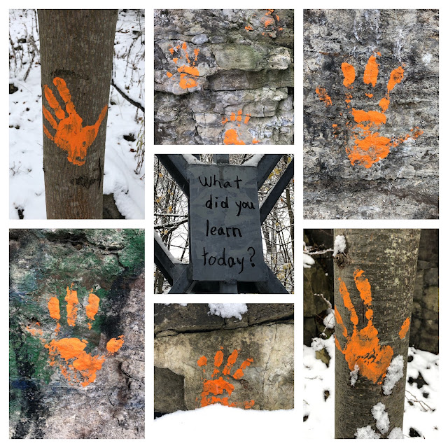
Several orange handprints adorned rocks and trees along the trail. We assume the hands represent the thousands of Indigenous children who were forcibly taken from their families and placed in residential schools. Many never returned and their families never learned what happened to them. The lasting effects of the abuse the children faced at the hands of the Canadian government and the church continue to impact Indigenous Peoples today. I'm not sure if "What did you learn today?" was related to the orange hands but it felt right to include it in the collage.

 |
| Princess Falls |
 |
| Princess Falls |
 |
| View of the Dundas Valley and the 403 from Princess Falls |
As we approach Scenic Drive we rejoin the Robert MacLaren Side Trail (named after a Hamilton doctor who was integral in the preservation of the Bruce Trail). If you read the previous blog post you may remember that we passed the Robert MacLaren Side Trail a few kms back. The Robert MacLaren Side Trail is a 2.3 km trail that forms a 4.5 km loop with the Bruce Trail.
Hike #20
Date: Nov 28th, 2021
Start: Chedoke Park
Finish: Scenic Drive
Distance: 2.6 km
Time: 40 min (1 hour 20 min round trip)
Difficulty: Easy paved path (very gradual climb)
Trail Use: Walking/Biking/Wheelchair Accessible
Total kms hiked: 123.8 kms
Kms remaining: 788.1 kms
Points of Interest in the Area: The house featured in The Handmaid's Tail (on the corner of Bay and Aberdeen); Dundurn Castle
 |
| The Handmaid's Tale House |
 |
| A picturesque house at the base of the escarpment |


Comments
Post a Comment